Fall conference season is upon us, and today we’re highlighting the dymaptic team attending the Kentucky Association of Mapping Professional...
As someone deeply entrenched in Geographic Information Systems (GIS) for over three decades, the recent advancements in datum models have piqued my interest. The transition to the North American Terrestrial Reference Frame of 2022 (NATRF2022) is a game changer for accuracy and the continued maintenance of geographic data. Not only does this affect the surveying community, but it also affects GIS users in various ways. These can range from how the data was captured, whether the data is accurate, and how much more metadata will need to be written to compensate for these new changes. But with such change comes questions, discussions, and debates, leaving a somewhat confusing landscape to navigate.
For ArcGIS users, Esri has announced that ArcGIS software will support the new reference frames, in alignment with the official release in 2025.
I recently had the privilege to talk with the Nebraska State Surveyor, Casey Sherlock, to shed some light on the strides made by the State of Nebraska along with the National Geodetic Survey (NGS) of the National Oceanic and Atmospheric Administration (NOAA) in preparing for NATRF2022. This new datum promises greater precision, starting with county-level specifications, progressing up to regional, and ultimately establishing a new statewide datum.
Our conversation proved engaging and enlightening, revisiting topics first discussed years ago and details gleaned from recent conferences and technical sessions. What follows is a recap of our conversation in Q&A format. Some of this may have a focus on Nebraska, but I have tried to keep a general perspective for all GIS practitioners.
Question: How does this new datum affect my state?
Answer: For Nebraska and all other states, this new datum will create a new State Plane Projection(s) along with other projections at the county and regional levels. This new set of coordinate systems will allow agencies and vendors to select the most appropriate projection for the job at hand while preserving data accuracy. The statewide and regional systems will be critical to any collected LiDAR or aerial imagery. NGS is working on establishing a set of core network reference points across the United States, along with developing the gravitational geoid model.
Q: What preparations does GIS data with a NAD83 datum need for the new datum?
A: Ensure datasets use NAD83 with a 2011 update, as the datum was slightly adjusted in 2011.
Q: What major change do you foresee for surveyors or GIS practitioners with this new datum?
A: Adoption of the international foot (ift) instead of the U.S. Survey foot (sft). This change, though seemingly minor in decimal places, significantly impacts northing, easting, and large-scale measurements.
Q: How can we prepare for the adoption of the international foot?
A: Ensure collection devices are configured for the international foot (ift), as most may default to the U.S. Survey foot (sft). Remember that the impact is minimal on numerically small distances and small coordinate values; however, on numerically large distances and large coordinate values, the impact is significant. In addition, metadata regarding units will be essential. For equipment, verify that the device converts among the three units (meter / ift / sft) correctly. Depending upon the equipment, some might not even recognize sft. For example, the HP35, a simple calculator to help a surveyor with calculations, does not convert all three units; however, the HP48 does.
A future practice would be adopting data collection in meters as the primary unit, then converting to sft or ift. It would make the conversions generally less error-prone regarding units and conversions.
Q: Are there any problematic aspects with the NAD83 adjustments?
A: The 1995 adjustment requires re-projection to the original 1983 and then to the 2011 update. Data captured with HARN adjustments should be forward compatible. The NGS Coordinate Conversion and Transformation tool (NCAT) will allow for the direct conversion from NAD83 (1995/HARN) forward to 2011 or the new 2022 datum. NACT was designed to eliminate complexity for the user.
Q: Are there lesser-known aspects of the new datum?
A: NGS will use the gravitational field to create a gravity-based geoid model. The gravity-based geoid model will determine orthometric heights directly from ellipsoid heights. Accurate orthometric heights will be available without the necessity for long-distance leveling campaigns. We will have high-accuracy vertical data without the need for physical marks on the ground. For example, technological advancements consider a focus on the I-80 corridor in Nebraska, gravitational fluctuations, and a crucial component—time.
Q: Can you elaborate on the significance of the time component?
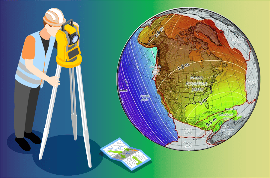
A: Recording date and time during coordinate capture is vital. The new datum operates in real time and considers the Earth's constant shifts due to plate tectonics, significantly impacting property boundaries and legal aspects. NGS will need a date/time on all survey measurements to properly account for the never-ending rotation of the North American Plate. The date/time should be added to the metadata for all datasets.
Q: How does the new datum affect Universal Transverse Mercator (UTM) and U.S. National Grid (USNG) projections?
A: With the modernized National Spatial Reference System (NSRS), the NSRS coordinate becomes the input to UTM, and the output changes accordingly. For example, if the new Lat/Lon is +1 meter N and +1 meter W, then the new UTM coordinate would be about 1 meter bigger in the Northing and about 1 meter smaller in the Easting, with tiny changes in scale factor and grid convergence.
Q: Does NATRF2022 present some opportunities as well as challenges?
Yes!! Several.
a) Current Readiness
Database hygiene is easy to put off into the future. Management now has the incentive to ensure that all new projects capture the needed metadata elements and to examine and correct the metadata for prior projects.
b) Infrastructure Improvements
The new datum will be delivered primarily by the NGS Continuously Operating Reference Stations (CORS) network, NGS Online Positioning User Service (OPUS) tools, and the NGS gravity-based geoid. Expanding the CORS network on a planful statewide basis and considering a statewide real time network are timely opportunities.
c) Planning for the Future
Submitting OPUS Share observations today on existing and new passive marks will create current NAD83(2011) coordinates (lat/lon/ellht) and a GPS-derived NAVD88 orthometric height for use today and automatically pre-populate future NATRF2022 coordinates and NAPGD2022 height when they are released. In this way, all parts of the state can access current and future data.
d) Opportunity to examine current database structure to ensure the new datum can be accommodated.
As a GIS practitioner, my biggest takeaways are:
-
Set current datasets datum to NAD83 (2011). This will help with reprojection to new datum and adjusted projections.
-
Configure all field collection devices to international feet.
-
Incorporate attributes for time in your data schema while collecting data.
-
Make sure that your metadata captures units and time
As the geospatial landscape evolves, these considerations will pave the way for a smoother transition into the era of NATRF2022.
For assistance with managing your dataset, updating applications, or anything else that would help your team optimize your GIS, reach out today to start a conversation with our team.
Related articles


As any CGP Grey fan knows, hexagons are indeed the bestagons. But here at dymaptic, we're not just on the hexagon bandwagon because they loo...

As a software developer on a busy development team, I typically spend my time working with coworkers and customers on the projects that we p...