In my previous post, I showed you how to get up and running with ASP.NET Blazor web development. In this post, I will show you how to use the IJSRuntime feature of Blazor to call into JavaScript and use Esri’s ArcGIS API for JavaScript from within your C# application to create modern web mapping apps.
Calling into the ArcGIS JavaScript API
@page "/"
    @inject IJSRuntime JsRuntime

    <PageTitle>Index</PageTitle>
    <div id="view-div" style="height: 100%; width: 100%"></div>

    @code {
       protected override async Task OnAfterRenderAsync(bool firstRender)
        {
            await base.OnAfterRenderAsync(firstRender);
            await JsRuntime.InvokeVoidAsync("renderMap");
        }
}<div>
element with an id and then using the lifecycle event OnAfterRenderAsync to call into the IJSRuntime interface and invoke a JavaScript function by name.window.renderMap = () => {
require(["esri/config","esri/Map", "esri/views/MapView"], function (esriConfig,Map, MapView) {
esriConfig.apiKey = "YOUR_API_KEY";
const map = new Map({
basemap: "arcgis-topographic" // Basemap layer service
});
const view = new MapView({
map: map,
center: [-118.805, 34.027], // Longitude, latitude
zoom: 13, // Zoom level
container: "view-div" // Div element
});
});
};I won’t explain this code in detail. If you want more information, check out Esri’s ArcGIS API for JavaScript documentation. Note that you will need a free ArcGIS Developer account and to get an API Key from the Developer Dashboard. Enter this key in line 4 above. Use this for testing purposes only. You probably want to pass this in from somewhere secure for production.
<link rel="stylesheet" href="https://js.arcgis.com/4.23/esri/themes/light/main.css">
<script src="https://js.arcgis.com/4.23/"></script>
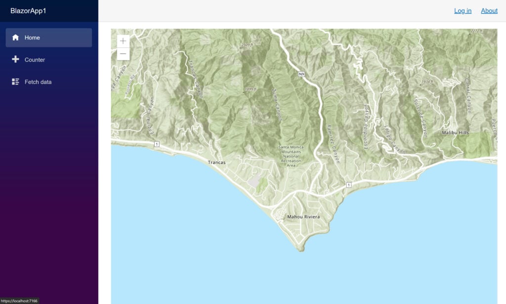
<script src="exampleJsInterop.js"></script>height: 100%;. This is necessary to get the content <div> to expand along with the view-div.That’s it! Run your application again, and you should see a rendered map on the home page! Congratulations on creating your first ArcGIS web mapping app!

Wrapping the ArcGIS JavaScript API
<MapView Longitude="_longitude" Latitude="_latitude" Zoom="11" Style="height: 400px; width: 100%;">
    <Map ArcGISDefaultBasemap="arcgis-topographic">
        <LocateWidget UseHeadingEnabled="false" ZoomTo="1500" />
        <SearchWidget />
        <GraphicsLayer>
            <Graphic>
                <Point Longitude="_pointLong" Latitude="_pointLat"/>
                <SimpleMarkerSymbol Color="@(new MapColor(226, 119, 40))">
                    <Outline Color="@(new MapColor(255, 255, 255))" Width="1"/>
                </SimpleMarkerSymbol>
            </Graphic>

            <Graphic>
                <PolyLine Paths="@_mapPath" />
                <SimpleLineSymbol Color="@(new MapColor(226, 119, 40))" Width="2"/>
            </Graphic>

            <Graphic>
                <Polygon Rings="@_mapRings"/>
                <SimpleFillSymbol Color="@(new MapColor(227, 139, 79, 0.8))">
                    <Outline Color="@(new MapColor(255, 255, 255))" Width="1"/>
                </SimpleFillSymbol>
                <Attributes Name="This is a Title" Description="And a Description"/>
                <PopupTemplate Title="{Name}" Content="{Description}"/>
            </Graphic>
        </GraphicsLayer>
    </Map>
</MapView>
Stay tuned for another follow-up post where I will share a new, upcoming Blazor ArcGIS API Wrapper NuGet package created by dymaptic but open-source and free to use! And remember to get in touch on Twitter, @TimPurdum, or @dymaptic, and let us know how we can help you in your development journey!


